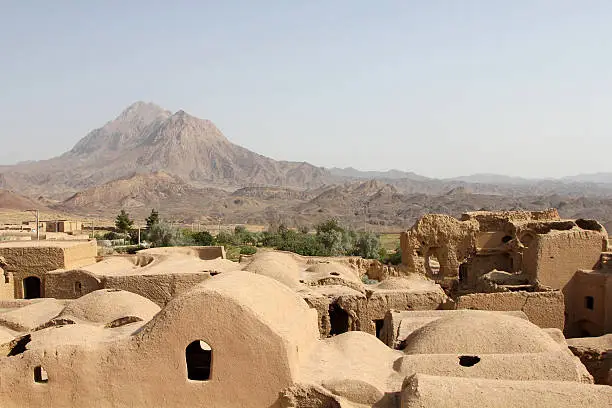
Harireh (Ruins of the Ancient City)
On the northern coast of Kish Island, the Harireh ruins are the remains of a thriving medieval port city (10th–14th centuries), built in coral stone overlooking the Persian Gulf.
On the northern coast of Kish Island in the Persian Gulf, the Harireh ruins are the remains of a prosperous medieval city that served as one of the region's major trading ports between the 10th and 14th centuries. Abandoned after a gradual decline, the city now sleeps beneath sand and sun, offering a striking contrast to Kish's modern resort complexes.
Quick Practical Info
- Access: open-air site, reachable by car or taxi from Kish town centre
- Admission: typically free (open-air archaeological site)
- Suggested duration: 30 to 60 minutes
- Dress code: Islamic dress mandatory for women (hijab, covering clothing)
What You'll See
The site reveals house foundations, coral stone walls, and the outlines of a mosque. Coral stone, a typical building material of the Persian Gulf, gives the ruins their characteristic texture and hue. Informational panels dot the pathway. The sea is visible from certain vantage points on the site.
History and Context
Harireh was founded around the 10th century and reached its peak between the 11th and 13th centuries, when Kish was a major stopover on maritime routes connecting Persia, India, and East Africa. The city had several thousand inhabitants, marketplaces, public baths, and places of worship. Its decline coincided with Hormuz's rise as the dominant port of the gulf. Archaeological excavations have uncovered ceramics, glass objects, and coins testifying to the intensity of commercial exchange.
Highlights of Your Visit
The Coral Stone Walls
Blocks of quarried coral, still standing in places, showcase the craftsmanship of medieval gulf builders. This local material, porous and heat-resistant, was quarried from surrounding reefs.
The Mosque Remains
The main mosque's floor plan remains legible at ground level. It is one of the site's best-preserved features and a landmark for understanding the city's urban layout.
Views of the Persian Gulf
From the northern section of the site, the turquoise waters of the Persian Gulf come into view. This panorama recalls why this location was chosen to establish a port.
Etiquette and Visiting Rules
- Hijab is mandatory for all women, whether foreign or Iranian.
- Do not climb on or move the stones of the ruins.
- Respect areas marked off by archaeologists.
Photography Tips
Early morning and late afternoon light is ideal: it accentuates the coral stone's textures and avoids harsh midday shadows. The contrasts between the ochre ruins and the gulf's blue sky are particularly photogenic from the site's northern angles. No known photography restrictions apply on site.
Location and Access
Harireh lies on the northern coast of Kish Island, a few kilometres from the town centre. The island is accessible by domestic flights from Tehran, Shiraz, and other Iranian cities. On the island, taxis and rental vehicles are the standard means of transport. The site is open-air and the terrain is relatively flat, though not adapted for people with reduced mobility.
Nearby Attractions
- Kish Island — free-trade zone in the Persian Gulf, with beaches, shopping centres, and water activities.
- Kish Aquarium — showcase of Persian Gulf marine life, worth visiting alongside the ruins.
- Kish Underground City (Kariz) — network of ancient water galleries converted into an underground cultural and commercial space.
Frequently asked questions
Winter (November to March) is the most pleasant season on Kish: temperatures are mild and visiting an open-air site is comfortable. In summer, Persian Gulf heat can exceed 40 °C, making midday visits exhausting.
In Iran, wearing a hijab is mandatory for all women in public spaces, including open-air archaeological sites. Covering clothing is required. For men, modest dress is recommended.
Yes. The Kariz underground city and Kish Aquarium are easily accessible the same day. Since Harireh is a brief visit (under an hour), it fits well into a broader island itinerary.
No photography restrictions are noted on this open-air archaeological site. However, it is best practice not to photograph people without their consent.
The terrain is generally flat but not equipped: no paved pathways or ramps. Access may be difficult for wheelchair users or those with very limited mobility.
Interested in this visit?
We can include it in your personalised itinerary.